

This presentation discusses the rejection by some geologists of Saginaw Bay as an extraterrestrial impact location 12,900 years ago. The major objection is that Saginaw Bay was not covered with ice at that time, and thus, no glacier ice boulders could have been launched from that location by an extraterrestrial impact.
My paper titled "A model for the geomorphology of the Carolina Bays", published in 2017, proposed that the Carolina Bays are the remodeled remains of oblique conical craters formed on ground liquefied by the seismic shock waves of secondary impacts of glacier ice boulders ejected by an extraterrestrial impact on the Laurentide Ice Sheet. The paper referenced the work by Davias and Gilbride that had identified Saginaw Bay as the convergence point of the projections of the major axes of the bays.
I referenced a 2002 paper by Dyke that illustrated Saginaw Bay covered with ice and I said that an impact by a meteorite at this location would have ejected chunks of ice in ballistic trajectories, and that the heat of the impact would have melted some ice to produce water and steam.
Due to the large energy of formation, my paper concludes that the time of formation of the Carolina Bays and Nebraska Rainwater Basins must coincide with an extinction event in the eastern half of the United States and the onset of a period of global cooling. This combination of conditions is best met by the disappearance of the North American megafauna, the end of the Clovis culture and the onset of the Younger Dryas cooling event at 12,800 calendar years before the present. The report of a platinum anomaly typical of extraterrestrial impacts at the Younger Dryas Boundary by Petaev et al. 2013 supports this scenario.
Two years after my paper was published, Randall Schaetzl and four co-authors disputed a gravity anomaly reported in a paper by Klokočník and the ice cover over Saginaw Bay that was discussed in my paper.
Schaetzl and his co-authors said that long-established data clearly indicate that the Laurentide Ice Sheet had retreated from the Saginaw Bay region well before 12,900 years ago. By this time, most of ancestral Lake Huron was ice-free, and had become part of Glacial Lake Algonquin. Certainly, the Saginaw Lowlands would have been open water and/or dry land at this time. A meteorite impact onto an ice sheet in the Saginaw Bay area would have been simply impossible, based on this timeline. In short, ice did not occupy the Saginaw Bay region – or even any part of the Saginaw Lowlands - at the time that this putative impact could have occurred; this is the crux of the argument given by Klokočník et al. (2019) for the lack of an impact structure. And thus, such an impact could not have dislodged "ice boulders" that could then have been ejected to great distance to form features such as the Carolina Bays (Zamora, 2017).
It is important to note that the objection to my paper was not about the elliptical geometry of the bays, or about the formation of the Carolina Bays by impacts. The only objection was that there was no ice in Saginaw Bay 12,900 years ago. Since this is the only objection, the Glacier Ice Impact Hypothesis could be modified to propose an earlier date when all geologists agree that Saginaw Bay was completely covered with ice. However, the time of the impact is very important. I have previously calculated that the kinetic energy required to make the elliptical basins in Marlboro County, South Carolina was approximately equivalent to 8 megatons of TNT per square kilometer. The high energy of emplacement of the Carolina Bays has to be associated with an environmental catastrophe, such as the megafaunal extinction 12,900 years ago. For this reason, adjusting the time of emplacement is not negotiable. There are two ways of going forward to gain acceptance from the geological community: 1) Maintain Saginaw Bay as the main impact point and prove ice coverage 12,900 years ago, or 2) Change the location of the extraterrestrial impact to correspond to an area where geologists agree there was ice 12,900 years ago.
William Blewett and two co-authors published a paper in 2013 titled: "New Age Control on the Port Huron Moraine in Northern Michigan". This paper is more recent than the references used by Schaetzl to claim that Saginaw Bay was not covered with ice 12,900 years ago and reaches the opposite conclusion. The abstract says that "Until now, radiocarbon age estimates of the Port Huron moraine in Michigan have been based largely on C-14 dates from beyond the state. This study reports a radiocarbon age of 12,960 ± 350 yr B.P. from sediments immediately proximal to the northwestern part of the Inner Port Huron moraine in Michigan's Southern Peninsula."
In this image, we can see that the Port Huron moraine curves around Saginaw Bay. This indicates that a glacier covered Saginaw Bay 12,960 years before the present as determined by Blewett.
Of course, a skeptic can quibble and say: 12,960 is just an estimated value. The uncertainty of plus or minus 350 years means that the date can range from 13,310 to 12,610. If the ice was gone by 13,310, Saginaw Bay would not have been covered with ice 12,900 years ago at the time of the impact. This example illustrates the difficulty of trying to prove that Saginaw Bay was covered with ice at the time of the impact. There will always be some uncertainty that will prevent many geologists from being convinced.
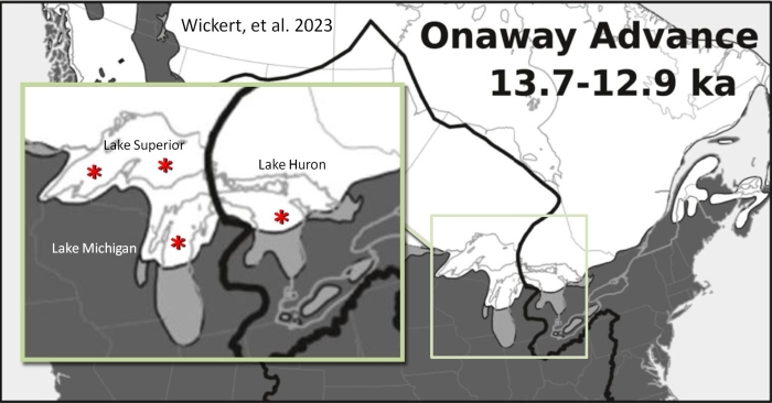
The second option to gain acceptance for the Glacier Ice Impact Hypothesis is to change the point of impact to areas where geologists agree that there was ice 12,900 years ago. Using the latest marine-calibrated chronology of the Laurentide Ice sheet advance and retreat published by Wickert, et al. in 2023, there are four potential areas: The deepest part of Lake Huron, which is directly aligned with Saginaw Bay, the Chippewa basin in Lake Michigan, and the east and west parts of Lake Superior. The strongest evidence supports the Chippewa basin in Lake Michigan as the point of an extraterrestrial impact.
We can use the data in the 2010 presentation by Davias and Gilbride to support an extraterrestrial impact in Lake Michigan. The paper reports a convergence of the Carolina Bays at latitude 43.5 degrees north and longitude 89.5 degrees west. The Coriolis Effect that takes into consideration the rotation of the Earth at this latitude corresponds to 20.1 kilometers per minute of flight time.
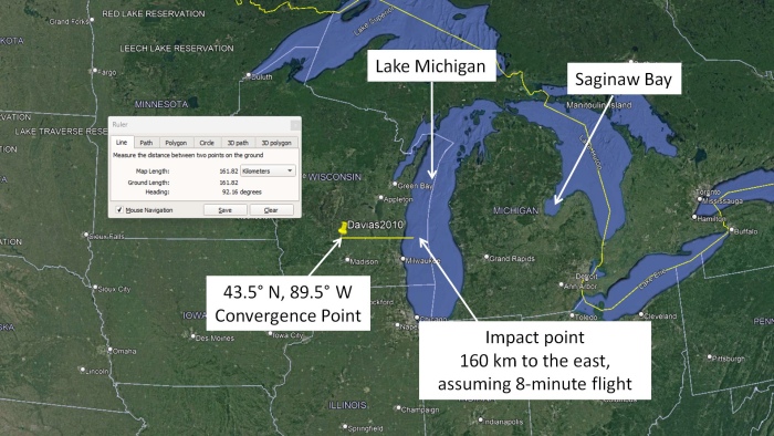
The eastward rotation of the Earth would cause a perceived westward displacement of 160 kilometers of the origin of the ice boulders launched on an 8-minute flight. This places the site of the extraterrestrial impact and the origin of the ice projectiles exactly in Lake Michigan, which was covered with ice 12,900 years ago. The Davias and Gilbride 2010 paper says that Saginaw Bay was selected heuristically, although it is about 400 kilometers away from the convergence point.
Associating Saginaw Bay with the convergence point would require 20-minute ballistic flights, but the calculation of flight times for various distances and launch angles for typical Carolina Bays only support flight times of 6 to 9 minutes. Flight times of eight minutes are more representative of the ballistic sedimentation of the glacier ice ejecta, and this means that Lake Michigan was the most likely site of an extraterrestrial impact.
In my own research, the majority of the lines extending the major axis of the Carolina Bays and Nebraska Basins intersect in Wisconsin, just west of Lake Michigan. This agrees with the convergence point found by Davias.
There are other intersection points, including some close to Saginaw Bay. For this reason, an extraterrestrial bombardment by multiple comet fragments cannot be excluded. The extensions of the major axes of the Nebraska Rainwater Basins and the Carolina Bays seem to have several convergence points.
The headings of the elliptical basins in Iowa point toward Lake Superior and the Chippewa Basin of Lake Michigan. This provides additional support for the hypothesis that multiple fragments of a comet impacted the Laurentide Ice Sheet 12,900 years ago.
It is important to know how glaciers flow in order to understand how geologists determine the extent and timing of the advances and retreats of a glacier. The University of Colorado has an interactive glacier simulator. There is a link to the program in the description of this video. The glacier simulator is controlled by two parameters: temperature and snowfall. A rise in temperature increases the rate of melting and causes the glacier to retreat, whereas a decrease in temperature causes the glacier to advance. Snowfall has the opposite effect. An increase in snowfall causes the glacier to advance, whereas a decrease in snowfall causes the glacier to retreat. Glaciers pick up rocks as they move over the terrain and they drop them when the ice melts. The stones create a record of the movement of the glacier. A glacier stops advancing and retreating when the temperature and snowfall are in dynamic equilibrium. This means that the rate of melting is equal to the rate of growth. Even though the ice front of the glacier does not advance or retreat, the ice continues to flow and rocks carried by the ice accumulate at the forward boundary of the glacier forming a moraine. The front of the glacier may stay stationary for hundreds or thousands of years. When the ice finally melts and retreats, the landscape is littered with erratic boulders and moraines that can be used to determine the flow of the glacier. As the glacier retreats, blocks of ice may break off and become partially buried in sediment and slowly melt, leaving behind a pit. These pits are called kettles, and when they fill with water, they are called kettle lakes.
The footprint of a glacier can be determined long after a glacier is gone by examining the moraines and erratic boulders deposited when the ice melted. Organic material found in the moraines can be radiocarbon dated to determine the time of the advances and retreats of the glacier.
But what happens when a glacier is struck by a comet fragment? Professor Peter Schultz from Brown University has demonstrated many times that a hypervelocity impact on an ice sheet ejects pieces of ice in ballistic trajectories from the impact site. Suppose that the Laurentide Ice Sheet completely covered Saginaw Bay. An extraterrestrial impact at that location would have ejected the rock-laden ice before the glacier had time to melt and deposit the rocks to form moraines.
By launching away the pieces of the glacier containing the rocks, the extraterrestrial impact prevented the formation of the features that geologists use to determine the extent of the ice coverage. For this reason, we can never be sure of the extent of the ice coverage at ground zero of an extraterrestrial impact on an ice sheet. It is not easy to establish a new hypothesis about the origin of the Carolina Bays.
